Back when I was talking about the Wagon Wheel Ruts in Wyoming, I miss-stated the name of the cliff where past travelers carved their names. It was not "Record Cliff", it was "Register Cliff". In looking for some pictures of what we saw, I came across the following site, which I will also add to the affected posting. Thanks to Daniel for his permission to link to his site.
http://www.eg.bucknell.edu/~hyde/jackson/lindaOregonTrip.html
The site includes pictures of both Register Cliff name carvings, and the ruts cut in stone.
I think I have all the other typos out, now, too.
Friday, October 13, 2006
For the bikers in the audiance
When we pulled into Tupalo we found a motel a bit off the beaten track (well, it was out of the main part of town, but close to the Natchez Trace). It had been pouring down rain for the previous hour, and it was dark. We found out later that this same storm had caused extensive flooding and even been responsible for several deaths further North. We were happy to find nice accommodations; initially we were somewhat worried by the characters that pulled in around the same time we did. One couple, however, did not worry us in the least. They were riding an older BMW R75/7 (I think) and had the neatest motorcycle trailer I have ever seen. I didn't get any pictures (wish I had) but I did get the name of the trailer, and talked to the owner in the morning. The trailer was designed and built for some years in New Zealand, and the company name was recently purchased and the trailer is now being manufactured here in the US. The owner sang high praises for the trailer, which, since it has only one wheel, handles exceptionally well. Their bike, trailer, and rain gear had kept them dry even in the nasty storm we had come through, together, as it turns out. We had our wipers on "high" for most of the storm -- it couldn't have been too much fun for them. I've been out in that kind of weather on a motorcycle, myself. Anyway, here's some links to the Uni-Go that I found on the Internet:
http://www.uni-go.com/
http://www.uni-go-trailers.com/
http://www.uni-go.com/
http://www.uni-go-trailers.com/
Forced hiatus
A few months back my physical exam turned up an umbilical hernia -- which explained the odd pain I had experienced there from time to time. I had surgery scheduled the week we returned from our road trip, and was tempted to postpone it until things started to get worse during the trip. So, the surgery went as planned Wednesday, two days ago, and I thought I would have some down time to catch up, maybe even finish this trip. Alas, I did nothing but sleep Wednesday evening, and yesterday was in too much pain to do much of anything after I got home from an abbreviated day at the office. Things feel much better this morning.
Saturday, October 07, 2006
Mill Creek WA -- The end of the trip, but not the blog.
Home at last. Another high mileage day (615) with an hour break in Spokane to check in on Marilyn's brother (he is recovering, but as of Friday afternoon, his doctor was still not entirely happy with everything, so they are keeping him another day). We stopped for lunch in Moses Lake -- El Rodeo's Mexican restaurant is very good. Since Tamales are made with white corn (Masa), I can usually find something without wheat in Mexican restaurants. Not much to say about the day except that Butte has a really pretty setting, and the Western mountains are way different than the Eastern ones! We crossed the Continental Divide coming into Butte at about 6900 feet, and the ride into Spokane was mostly down hill. Spokane to home is an easy 4 hour drive, so we pressed on over the Cascades and arrived home at about 7:00 last night.
Lots of chores to do this morning, so this will have to do for now.
For the readers not completely bored at this juncture, remember I left off in the middle of the Natchez Trace. I will pick up the detailed story line at the birth place of Elvis Presley, Tupalo Mississippi, and maybe trace his path North to Nashville Tennessee.
Butte MT
We did take a quick tour through Sturgis, where we found the best Espresso yet, and Deadwood, which has been using its gambling money wisely to fix up the town. The last time we were though here in late 1999, there were buildings which had not been touched since the late 1800's. Now these buildings were in pretty good repair, and still authentic, just not in danger of falling down in a strong wind! Some period paint was in evidence, and the whole town had a new life. Now if they could just do it without all the stupid slot machines and such....
Reasonable speed limits allowed us to travel about 622 miles today, and we are both tuckered out.
More to follow.
Reasonable speed limits allowed us to travel about 622 miles today, and we are both tuckered out.
More to follow.
Rapid City, SD
South Dakota has Bill Boards. Lots. Wall Drug. Reptile Gardens. 1800's Town. 12 foot tall Prairie Dog. Too many to name -- but will post some pix ASAP.
We took a quick swing through the Badlands, which are as scenic as ever, and since this is late in the season, and was late in the day, we had the road pretty much to ourselves. We stopped at the old homestead hoping to see a friend we had made years ago on another trip through the region, but she wasn't there. The docent on duty, however, had her phone number and called her for us, so we got to talk to her and re-exchanged mailing addresses.
Wednesday morning found us in Rapid City SD, and unfortunately we cannot begin to do justice to this area. Deadwood. Boot Hill. Sturgis. Crazy Horse. Mount Rushmore. Black Hills. Pigtail Bridges. We have seen it all before, of course, but still, it will be a real pity to just pass it by this year. We need to be in Spokane by Friday to see Marilyn's brother who will be undergoing some surgery, and time will have to be managed carefully if we are to make it.
I have not been feeling well since dinner back in Worthington. I chanced some Cajun Seasoned fish, and they must have used flour to bind the seasoning. I am gluten intolerant (mild Celiac disease) and so must avoid all wheat products. Hence, not much writing -- just wasn't up to it.
Wednesday, October 04, 2006
Worthington, MN
We transitioned from the fall-colored forested hills of Wisconsin to the flat windy prairies of Minnesota, passing through the birthplace and wintering grounds of famous circuses in Baraboo Wisconsin and an Amish community in Minnesota. Today we are heading for the Corn Palace and the Bad Lands, and Wall Drug and then points West. Gotta go!
Tuesday, October 03, 2006
Rockford IL
We spent an extra day in DC and went out to Mount Vernon, George Washington's home, then made a bee line for the Amish area in Northern Indiana to find a nice quilt. While there we heard about the horrific events that unfolded in West Nickle Mines, Pennsylvania. Lightning storms followed us all the way here, and we got shaken down by the Illinois toll roads more times than we remember. More on all of this later. . Right now we need to shake some dust.
Saturday, September 30, 2006
Day 8 -- Natches MS to Tupelo MS
Tracing the footsteps of the flatboatmen...
If we had skipped the Southern-most portion of the Natchez Trace, we would have missed the very best.


Natchez has a fascinating history that I cannot began to do justice to. I'll just talk about some of the things that stuck with me. Natchez was an important trading outpost very early in the settlement of the Southeastern portion of the continent. It has been under Indian, French, Spanish, English, and US control. After the Natchez Trace was made into a "road" of sorts by the Army in 1801 to 1802, Natchez was tied fairly directly to the North. Thus when talks of secession began, Natchez was more of a Northern town than a Southern; still, when Mississippi voted to secede from the Union, Natchez threw it's support behind the state, causing families and neighbors to divide their allegiances. Being so far removed from the main areas of conflict, Natchez was undamaged from the Civil War and thus retains most of its historic buildings, including businesses, homes, and the mansions of wealthy plantation owners, lawyers, and businessmen. In 1830 the first steamboat docked at Natchez, and from that time on, the Natchez Trace, and the town of Natchez, declined in importance as the port of New Orleans and the Mississippi River took their places. The Civil War took a huge toll on the South in terms of financial strength, and once the war was over, the Cotton Boll Weavel completed the devastation of one of the South's key industries. In talking to some of the locals, it is my impression that many areas of the South, Natchez included, are only now making any kind of a come back, and most of that is based on tourism. Pictured here is the Kings Tavern, reputed to be haunted, with great prime rib, and the oldest building in Natchez.

We found the Natchez Coffee Company, a very nice espresso and ice cream shop, for our morning wake-me-up, and then decided to tour one of the magnificent antebellum homes nearby. We chose the "Melrose" -- http://www.nps.gov/natc/historyculture/places.htm -- and -- http://travel.yahoo.com/p-travelguide-2990729-melrose_natchez-i -- as it is the best-preserved of all the Natchez homes, due to its being in the ownership of only two families before its sale to the National Park Service.

Built by a wealthy lawyer who later became a plantation owner, as well, the house, grounds, and outbuildings are stunning examples of the very best craftsmanship of its time. All the original furniture and furnishings still exist. The style is Neo-Grecian, with columns supporting the upper stories. After several family tragedies, the first owners sold the entire estate to another family who passed it down until the last one, still making her home there, died in, I think, 1979. The tour is well done, and we were allowed access to the first and second floors of the home, and one building that was one of the slave quarters. This brings up the juxtaposition of exquisite beauty and profound misery, as all of the manual labor required to run the house and keep the grounds came from slaves who lived on the grounds.
Architectural features helped make the house livable -- the attic features opening windows that served to draw air up through the structure, which would have helped cool it. A full basement was used to store furnishings not in use and various food items in relative coolness.

A foot trail used by several different Indian tribes and nations between Natchez and the Nashville area existed for centuries. The Mound Builders, or "Upper Woodland People" build burial and ceremonial mounds along the Trace. Natchez was an important port city, and became a banking center, home to plantation owners, and supply depot.

Traders and trappers would journey from their homes in the Northeast into the Missouri and Mississippi River systems, build "flat boats" -- glorified rafts, really, and start downstream gathering furs and trading as they went, until they reached Natchez. There they would sell their boats for the lumber in them, sell any remaining goods, buy supplies, and start North on the Natchez Trace either on foot or horseback. The journey back to their homes could take as long as 6 months through the snake and insect-infested swamps and woodlands, and at any point they could be set upon by thieves, wild animals, or renegade Indians. Places to sleep or get a meal were scarce -- known as "stands", they may or may not have anything to offer, as they themselves were dependant on the Trace for supplies. Still, the Trace was the only reasonable way to make your North at that time, and unlike the Oregon Trail, where wagons would spread out for miles across the prairie, the Trace was essentially a single-file foot path that countless feet and years of erosion wore deep into the land. Today there are places where the Trace is 8 feet or more below grade, a U-shaped cut that is twenty or so feet across.

The section of the Trace between Natchez and Jackson contained many examples of "sunken" traces, and is, I think, the most scenic portion of the modern 2-lane road which comprises the Trace today. Traces of the original Trace can be seen in many areas, and there are many historic sites just short walks from the road. And there are places where one can walk on the original Trace, literally in the foot steps of such legendary figures as Davy Crockett, Daniel Boone, and Meriweather Lewis. More on him, next time.
If we had skipped the Southern-most portion of the Natchez Trace, we would have missed the very best.
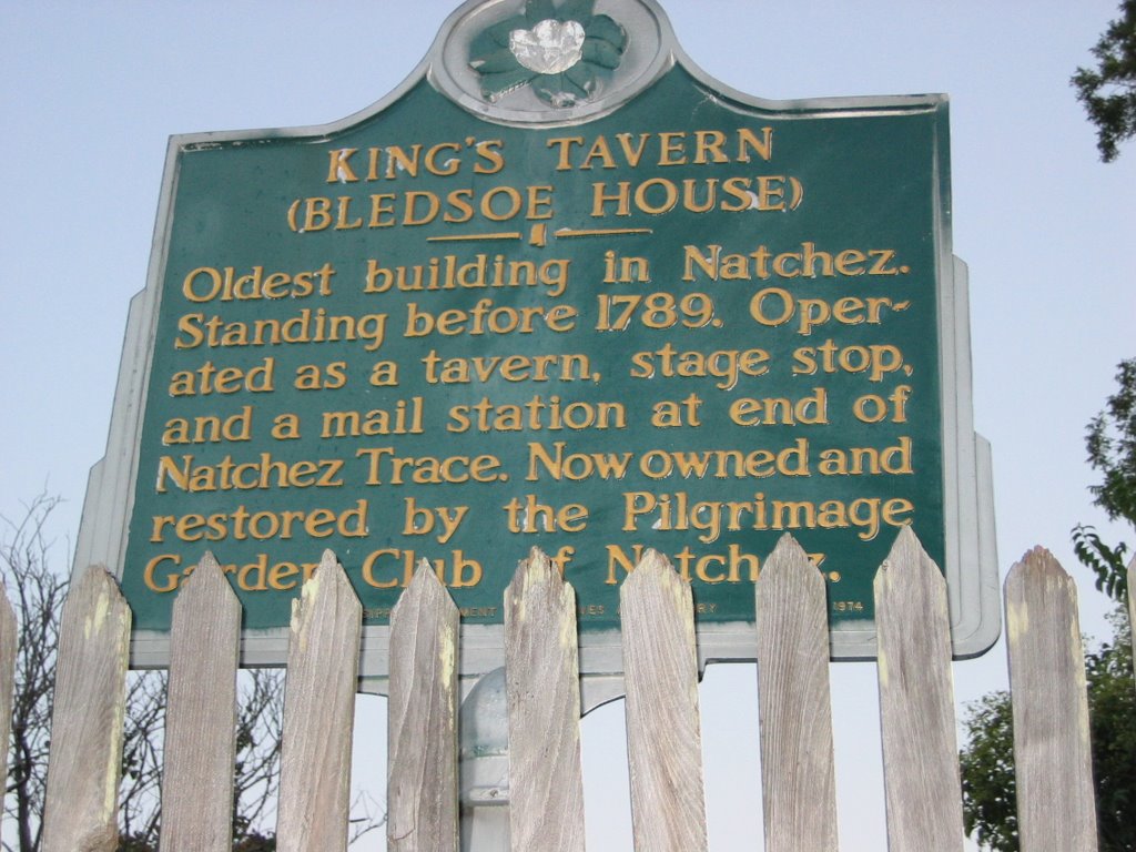

Natchez has a fascinating history that I cannot began to do justice to. I'll just talk about some of the things that stuck with me. Natchez was an important trading outpost very early in the settlement of the Southeastern portion of the continent. It has been under Indian, French, Spanish, English, and US control. After the Natchez Trace was made into a "road" of sorts by the Army in 1801 to 1802, Natchez was tied fairly directly to the North. Thus when talks of secession began, Natchez was more of a Northern town than a Southern; still, when Mississippi voted to secede from the Union, Natchez threw it's support behind the state, causing families and neighbors to divide their allegiances. Being so far removed from the main areas of conflict, Natchez was undamaged from the Civil War and thus retains most of its historic buildings, including businesses, homes, and the mansions of wealthy plantation owners, lawyers, and businessmen. In 1830 the first steamboat docked at Natchez, and from that time on, the Natchez Trace, and the town of Natchez, declined in importance as the port of New Orleans and the Mississippi River took their places. The Civil War took a huge toll on the South in terms of financial strength, and once the war was over, the Cotton Boll Weavel completed the devastation of one of the South's key industries. In talking to some of the locals, it is my impression that many areas of the South, Natchez included, are only now making any kind of a come back, and most of that is based on tourism. Pictured here is the Kings Tavern, reputed to be haunted, with great prime rib, and the oldest building in Natchez.

We found the Natchez Coffee Company, a very nice espresso and ice cream shop, for our morning wake-me-up, and then decided to tour one of the magnificent antebellum homes nearby. We chose the "Melrose" -- http://www.nps.gov/natc/historyculture/places.htm -- and -- http://travel.yahoo.com/p-travelguide-2990729-melrose_natchez-i -- as it is the best-preserved of all the Natchez homes, due to its being in the ownership of only two families before its sale to the National Park Service.

Built by a wealthy lawyer who later became a plantation owner, as well, the house, grounds, and outbuildings are stunning examples of the very best craftsmanship of its time. All the original furniture and furnishings still exist. The style is Neo-Grecian, with columns supporting the upper stories. After several family tragedies, the first owners sold the entire estate to another family who passed it down until the last one, still making her home there, died in, I think, 1979. The tour is well done, and we were allowed access to the first and second floors of the home, and one building that was one of the slave quarters. This brings up the juxtaposition of exquisite beauty and profound misery, as all of the manual labor required to run the house and keep the grounds came from slaves who lived on the grounds.
Architectural features helped make the house livable -- the attic features opening windows that served to draw air up through the structure, which would have helped cool it. A full basement was used to store furnishings not in use and various food items in relative coolness.

A foot trail used by several different Indian tribes and nations between Natchez and the Nashville area existed for centuries. The Mound Builders, or "Upper Woodland People" build burial and ceremonial mounds along the Trace. Natchez was an important port city, and became a banking center, home to plantation owners, and supply depot.

Traders and trappers would journey from their homes in the Northeast into the Missouri and Mississippi River systems, build "flat boats" -- glorified rafts, really, and start downstream gathering furs and trading as they went, until they reached Natchez. There they would sell their boats for the lumber in them, sell any remaining goods, buy supplies, and start North on the Natchez Trace either on foot or horseback. The journey back to their homes could take as long as 6 months through the snake and insect-infested swamps and woodlands, and at any point they could be set upon by thieves, wild animals, or renegade Indians. Places to sleep or get a meal were scarce -- known as "stands", they may or may not have anything to offer, as they themselves were dependant on the Trace for supplies. Still, the Trace was the only reasonable way to make your North at that time, and unlike the Oregon Trail, where wagons would spread out for miles across the prairie, the Trace was essentially a single-file foot path that countless feet and years of erosion wore deep into the land. Today there are places where the Trace is 8 feet or more below grade, a U-shaped cut that is twenty or so feet across.

The section of the Trace between Natchez and Jackson contained many examples of "sunken" traces, and is, I think, the most scenic portion of the modern 2-lane road which comprises the Trace today. Traces of the original Trace can be seen in many areas, and there are many historic sites just short walks from the road. And there are places where one can walk on the original Trace, literally in the foot steps of such legendary figures as Davy Crockett, Daniel Boone, and Meriweather Lewis. More on him, next time.
Friday, September 29, 2006
Day 7 -- From Clarksville AR to Natchez MS
"Way down in Louisiana, just about a mile from Texarkana..."
Friday dawned with clearing skies and a fresh clean appearance following the overnight rainfall. The bugs had been in full voice last night while I was enjoying the lightning storm and now the day shift was filling the air with, well, day-bug songs.

We headed South through Little Rock (well, around Little Rock -- the highway bypasses the city to the East), and picked up US-65 into Louisiana. Corn gave way to mile after mile of cotton fields ..."in dem ol' cotton fields back home". We were treated to harvest season. We saw lots of closed gin mills and some interesting equipment out in the fields. It appears that cotton ginning has gone mobile -- the fields are picked mechanically, cotton fed into mobile gins to remove the seeds, and then packed into special trucks that bale the cotton and transport it to the edges of the fields for later pickup. That's one in the photo to the left. Tarps are spread on top of the bales, and numbers, probably the supplier ID, painted on the sides.

About 30 miles outside of the little town of Lake Providence, we encountered a sight for Sore Seattle Eyes: it promised that somewhere ahead we would find "Jehovah Java". Ahhh.... now since leaving Wyoming, the most important, and sometimes most disappointing part of the morning ritual was finding espresso. I had offered to pack our LaPavoni for the trip, but Marilyn was sure that we would be able to find espresso on a regular basis. For once, I was right, but it was nothing to gloat about :-( Well, a sign closer to town again promised "Jehovah Java" ahead, and so we really started watching. We went though town, and saw a sign for a bakery, but no Joe. Hmmm.... Seems to me that the coffee should be close to the donuts, so we turned around and this time saw the sign pointing down another street. Oh bliss. The espresso was real good. Excellent, in fact. They import their beans from Seattle, and they ain't Starbucks! Starbucks, we both agree, is over-roasted and bitter and we only drink it when we are desperate. No, Jehovah Java was a real find and was a real nice coffee house with home made sandwiches and salads in a nice atmosphere. It was started by a Baptist minister who donates all his proceeds to his church and the shop, while obviously Christian, is tastefully so and doesn't smack you upside the head with preachiness.
On the way into Lake Providence we encountered a rain storm of biblical proportions -- the drops were as big around as marbles and bounced a foot off the pavement when they hit. I had the wipers on full throttle and still had a hard time seeing the edges of the road. It was dry while we enjoyed our lunch and espresso, and I noticed to my satisfaction that all the bugs had been washed off the car during the deluge. Just out of town we hit another rain squall almost as heavy as the first. It sure can rain down here!
We had been making good time so we decided to push on into Natchez instead of picking up the Trace in Jackson. So on we went further South, crossed the Mississippi, and pulled into the visitors' center about a minute before closing. There, a very nice young lady spent a good 15 minutes after her shift should have ended and told us how to get on the Trace in the morning, what we should do in Natchez -- and there is a lot to see there -- and even gave us motel recommendations. This sort of generosity and graciousness typified our interactions with everyone we met in Louisiana and Mississippi. It was a welcome change from our normal lives where it is common to have doors slammed in your faces if you show up close to quitting time.
We went to find the city's grand hotel, the Eola, but opted to look elsewhere when we heard the rates. But we did do a quick tour of downtown and were glad we decided to go the extra distance. Natchez is a wonderful old Southern town, spared from the destruction of the Civil War, and being renovated a bit at a time. We had to choose between a supposedly haunted prime rib place in the oldest Inn in the city, a place that has a reputation for the best steaks in town, or Fat Mama's Tamales with Knock You Naked Margaritas. Hoping for some good spicy food, we chose Fat Mama's. The tamales were OK, but too bland, and they only had pepper sauce to heat them up. What they really needed was some good green chili sauce. The margaritas didn't knock us naked, but they were pretty good. If I hadn't had to drive back to the motel I would have had a second one just to see what would happen :-) It was night time but hot and humid -- pretty miserable for a couple of people used to 65 degrees. The air conditioners poured excess moisture out of the rooms at such a rate that the walkways outside the rooms were slanted to take the water away from the building. Not much to do but crank it up towards "Ice Age" and hope that the room will get cool enough to sleep.
So this is where I started this blog, and once again it is way too late and I really need to get some sleep. We will do some tourist things here in Washington, D.C. tomorrow before we head towards the Indiana Amish community. Hopefully I will get a chance soon to write about the two fascinating days we spent coming up the Natchez Trace, our short day between Nashville and Knoxville, our shopping trip that included the Great Smoky Mountain Knife Company and the arts and crafts community out from Gatlinburg, the glimpse of the Biltmore Estate and Asheville, and the two days up the Blue Ridge Parkway. Ta ta for now...
Friday dawned with clearing skies and a fresh clean appearance following the overnight rainfall. The bugs had been in full voice last night while I was enjoying the lightning storm and now the day shift was filling the air with, well, day-bug songs.

We headed South through Little Rock (well, around Little Rock -- the highway bypasses the city to the East), and picked up US-65 into Louisiana. Corn gave way to mile after mile of cotton fields ..."in dem ol' cotton fields back home". We were treated to harvest season. We saw lots of closed gin mills and some interesting equipment out in the fields. It appears that cotton ginning has gone mobile -- the fields are picked mechanically, cotton fed into mobile gins to remove the seeds, and then packed into special trucks that bale the cotton and transport it to the edges of the fields for later pickup. That's one in the photo to the left. Tarps are spread on top of the bales, and numbers, probably the supplier ID, painted on the sides.
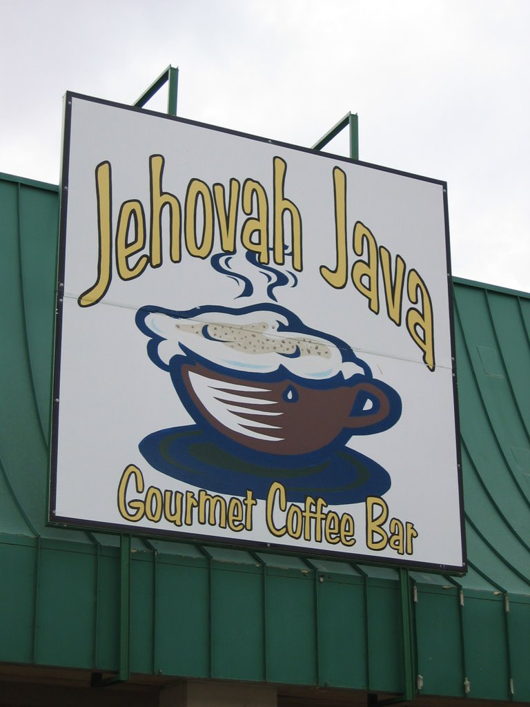
About 30 miles outside of the little town of Lake Providence, we encountered a sight for Sore Seattle Eyes: it promised that somewhere ahead we would find "Jehovah Java". Ahhh.... now since leaving Wyoming, the most important, and sometimes most disappointing part of the morning ritual was finding espresso. I had offered to pack our LaPavoni for the trip, but Marilyn was sure that we would be able to find espresso on a regular basis. For once, I was right, but it was nothing to gloat about :-( Well, a sign closer to town again promised "Jehovah Java" ahead, and so we really started watching. We went though town, and saw a sign for a bakery, but no Joe. Hmmm.... Seems to me that the coffee should be close to the donuts, so we turned around and this time saw the sign pointing down another street. Oh bliss. The espresso was real good. Excellent, in fact. They import their beans from Seattle, and they ain't Starbucks! Starbucks, we both agree, is over-roasted and bitter and we only drink it when we are desperate. No, Jehovah Java was a real find and was a real nice coffee house with home made sandwiches and salads in a nice atmosphere. It was started by a Baptist minister who donates all his proceeds to his church and the shop, while obviously Christian, is tastefully so and doesn't smack you upside the head with preachiness.
On the way into Lake Providence we encountered a rain storm of biblical proportions -- the drops were as big around as marbles and bounced a foot off the pavement when they hit. I had the wipers on full throttle and still had a hard time seeing the edges of the road. It was dry while we enjoyed our lunch and espresso, and I noticed to my satisfaction that all the bugs had been washed off the car during the deluge. Just out of town we hit another rain squall almost as heavy as the first. It sure can rain down here!
We had been making good time so we decided to push on into Natchez instead of picking up the Trace in Jackson. So on we went further South, crossed the Mississippi, and pulled into the visitors' center about a minute before closing. There, a very nice young lady spent a good 15 minutes after her shift should have ended and told us how to get on the Trace in the morning, what we should do in Natchez -- and there is a lot to see there -- and even gave us motel recommendations. This sort of generosity and graciousness typified our interactions with everyone we met in Louisiana and Mississippi. It was a welcome change from our normal lives where it is common to have doors slammed in your faces if you show up close to quitting time.
We went to find the city's grand hotel, the Eola, but opted to look elsewhere when we heard the rates. But we did do a quick tour of downtown and were glad we decided to go the extra distance. Natchez is a wonderful old Southern town, spared from the destruction of the Civil War, and being renovated a bit at a time. We had to choose between a supposedly haunted prime rib place in the oldest Inn in the city, a place that has a reputation for the best steaks in town, or Fat Mama's Tamales with Knock You Naked Margaritas. Hoping for some good spicy food, we chose Fat Mama's. The tamales were OK, but too bland, and they only had pepper sauce to heat them up. What they really needed was some good green chili sauce. The margaritas didn't knock us naked, but they were pretty good. If I hadn't had to drive back to the motel I would have had a second one just to see what would happen :-) It was night time but hot and humid -- pretty miserable for a couple of people used to 65 degrees. The air conditioners poured excess moisture out of the rooms at such a rate that the walkways outside the rooms were slanted to take the water away from the building. Not much to do but crank it up towards "Ice Age" and hope that the room will get cool enough to sleep.
So this is where I started this blog, and once again it is way too late and I really need to get some sleep. We will do some tourist things here in Washington, D.C. tomorrow before we head towards the Indiana Amish community. Hopefully I will get a chance soon to write about the two fascinating days we spent coming up the Natchez Trace, our short day between Nashville and Knoxville, our shopping trip that included the Great Smoky Mountain Knife Company and the arts and crafts community out from Gatlinburg, the glimpse of the Biltmore Estate and Asheville, and the two days up the Blue Ridge Parkway. Ta ta for now...
Day 6 -- From WaKeeney KS to Clarksville AR
A wild ride...
Marilyn sez:
Thursday we traveled through part of Kansas and Oklahoma into Arkansas – five hundred and sixty-four miles – keeping one step ahead of a tornado. The winds in Oklahoma were so strong it was hard to stand. Between Oklahoma and Arkansas we saw an incredible lightening show, but the rain did not hit until we were safe in our dumpy little hotel in the Arkansas Ozarks.
Tom adds:
Dumpy, yes, but it had wireless Internet!
It was time to do some laundry, and I was elected. Actually, as you may guess, only one vote counted! The washer and dryer were outside in a covered breeze-way, and while the load washed, I enjoyed watching the lightning and counting the seconds until I heard the thunder -- Sound travels around a mile in 5 seconds and the closest strike was less than half a mile away. Pretty intense!
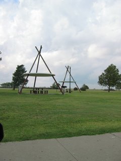
Back to the day's drive, the winds were extremely heavy, and from the side much of the day. Even Roxy was a bit unsettled as she took us in and out of the calms in the lee-sides of the semi's we passed. As night fell, the lightning ahead illuminated the clouds from the insides, an effect that was magical and eerie at the same time. Only a few pictures today, and they were of strange shelters in an Oklahoma rest stop. I couldn't figure out whether they were teepees, UFOs, or UFOs captured in teepees. Whatever, they were interesting.
The change in landscape was most noticeable today. We left the corn and wheat fields of Kansas where trees were scattered, planted mostly around houses for windbreaks or following gullies or along streams where they could find water. Gradually crossing Oklahoma in a Southeasterly direction, following the toll roads and then I-40, we saw more and more trees until finally in the Ozarks of Arkansas the plains were no more. Folded hills and then rocky outcrops, with heavily wooded valleys became rugged mountains with panoramic views. I'd like to spend some more time in the Ozarks -- they are prettier than I had thought they would be.
Since there isn't much else to say about the day's adventures, let me mention what has become our favorite restaurant chain -- Applebee's. They have a Caesar Salad that you can get plain, or with either steak or salmon, and both the steak and salmon have been consistently excellent. Plus, they serve wine so my co-pilot can get a little mellow and get her back to relax before we "shake some dust".
Day 5 -- Torrington WY to WaKeeney KS
From the Oregon Trail to the Red Brick streets of Oberlin....

The Nebraska AAA map marks US-26 as a "scenic" route, (their only one...) and does have some pretty sights. Scott's Bluff, Chimney Rock, and the Platte River make up a pleasant backdrop for the day's drive. We stopped at a few historic sites along the Oregon Trail, including the grave of Rebbecca ??? -- found by a railroad crew years later who showed their respect by bending the railroad right-of-way enough to leave the spot undisturbed. Also one of the spots where Narcissa Whitman, the first woman to traverse the Oregon Trail, camped with her husband and party on their way to found a mission near Walla Walla Washington. Unfortunately, after existing with the natives for some years, the Whitmans were killed when a passing wagon train brought measles, and hence, death, to the Cayuse Tribe: http://www.isu.edu/~trinmich/Whitman.html

Chimney Rock was the "half-way" point in the typical Oregon Trail passage, and so marked an important landmark for the tens of thousands who made the journey.

After rejoining I-80 (the replacement for old US-30, the Lincoln Highway), we continued on to North Platte where we headed South to find some traces of Marilyn's roots. Oberlin Kansas has the prettiest red brick streets I have ever seen. I remember seeing some remnants of brick streets in my home town of Grand Rapids, Michigan, but the Oberlin "brickyards" are kept in impeccable condition and are truly beautiful. Anyway, back to Marilyn's roots. Her grandfather Guy ran a hardware store and plumbing business in Oberlin, and for some time held the office of Mayor. Her great-grandfather had the first windmill in the area. http://www.oberlinkansas.org/towns/oberlin.html

Marilyn found her grandparents' old house, which now appears to be inhabited by "night people" and probably hasn't been painted since her grandfather passed away over 30 years ago. Wanna see the present occupants? Here they are on the front porch, quaffing a couple of brewskies...
We pushed on south through the night to I-70 and then headed East to a well-deserved rest in WaKeeney. Total mileage for the day was just under 400.

The Nebraska AAA map marks US-26 as a "scenic" route, (their only one...) and does have some pretty sights. Scott's Bluff, Chimney Rock, and the Platte River make up a pleasant backdrop for the day's drive. We stopped at a few historic sites along the Oregon Trail, including the grave of Rebbecca ??? -- found by a railroad crew years later who showed their respect by bending the railroad right-of-way enough to leave the spot undisturbed. Also one of the spots where Narcissa Whitman, the first woman to traverse the Oregon Trail, camped with her husband and party on their way to found a mission near Walla Walla Washington. Unfortunately, after existing with the natives for some years, the Whitmans were killed when a passing wagon train brought measles, and hence, death, to the Cayuse Tribe: http://www.isu.edu/~trinmich/Whitman.html

Chimney Rock was the "half-way" point in the typical Oregon Trail passage, and so marked an important landmark for the tens of thousands who made the journey.

After rejoining I-80 (the replacement for old US-30, the Lincoln Highway), we continued on to North Platte where we headed South to find some traces of Marilyn's roots. Oberlin Kansas has the prettiest red brick streets I have ever seen. I remember seeing some remnants of brick streets in my home town of Grand Rapids, Michigan, but the Oberlin "brickyards" are kept in impeccable condition and are truly beautiful. Anyway, back to Marilyn's roots. Her grandfather Guy ran a hardware store and plumbing business in Oberlin, and for some time held the office of Mayor. Her great-grandfather had the first windmill in the area. http://www.oberlinkansas.org/towns/oberlin.html
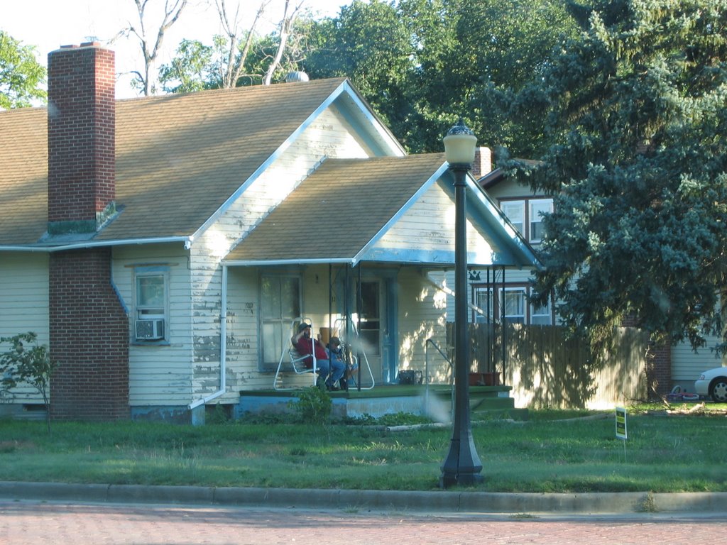
Marilyn found her grandparents' old house, which now appears to be inhabited by "night people" and probably hasn't been painted since her grandfather passed away over 30 years ago. Wanna see the present occupants? Here they are on the front porch, quaffing a couple of brewskies...
We pushed on south through the night to I-70 and then headed East to a well-deserved rest in WaKeeney. Total mileage for the day was just under 400.
Day 4 -- Great America WY to Torrington WY
Traces of Travelers...
We super-slabbed it across most of Wyoming today, and as I mentioned before, the average speed was well north of 90 MPH. On several occasions while passing trucks, the speedo exceeded the 100 mark; luckily my passenger either didn't notice, or didn't say anything for fear I would slow down and subject her to more minutes of Wyoming monotony :-) Roxy, our Infiniti FX-35 took the high speeds in stride, and only asked for a little more fuel than usual. Oh, and we did all this through head winds of at least 30 MPH. The ride was smooth and stable, and the aerodynamics of the FX seemed to prevent the buffeting I have experienced in previous similar situations.
After a late lunch / early dinner, we headed North on I-25 to trace the route of the Oregon Trail and the Platte River along US-26. Somewhere before the Fort Laramie historic site, in the middle of the small town of Guernsey, we followed signs to "Wagon Wheel Ruts" and discovered the really neat site that contains "Register Cliff" and real wagon ruts left by those who traveled the Oregon Trail many years ago. I say "real" because most such sites have wide U-shaped channels where many wagons went over the same area, such as a steep descent, and the animals pulling the wagons, and the wagon wheels, combined with years of water erosion, leave channels, not individual wheel ruts. These ruts, however, were different. The ruts are in solid stone. Yes, the steel-tired wagon wheels, thousands of them, cut deep ruts down into solid rock, sometimes two or more feet deep. One particular place still showed what was obviously a place where every draft animal placed it's right foot when starting the ascent up a steep rise. It, too, had to have been worn down from thousands of feet trying to find purchase while pulling the heavy loads. The effort required to make the journey from meeting places such as Saint Louis to eventual ends in Oregon, Utah, and Northern California is astounding, and took a heavy toll. Cholera was common, and all along the way we saw reminders that not all who started the journey made it all the way. At Register Cliff many travelers left their names and date of passage carved in the sandstone cliff, and one in particular is known to have died just a few weeks and 70 miles further down the trail, struck down in the prime of life by cholera. Yes, that's several weeks for 70 miles. Sometime the settlers made only 3 miles a day.
Marilyn and I were discussing what things we have now, things the settlers could have comprehended, that they would have been most impressed with. She thinks it would be the roads we have today. They would be familiar in concept, and they could use them with the technology they possessed, yet could go so much further using them as compared to hacking their way through prairie or struggling up rocky hills. Roads, more than anything else, I think, made this country into the magnificent thing it is today. President Eisenhower is credited with being the father of the Interstate System, but even the great roads that were replaced, such as Route 66 (The Mother Road), the Lincoln Highway, the Yellowstone Trail, the Sunset Highway, and the National Road, to name a few, were more than some countries have today. Before, 3 miles a day, now, and I have done it when I was younger and stupider, 1000 miles a day -- could the Oregon Trail users comprehend three orders of magnitude increase in daily mileage? I wonder....
We, ourselves, made nearly 500 miles on this day and still had time to spend 3 hours exploring the traces left by others.
Unfortunately, no photos, as it appears the camera memory card acted up. The images come up in thumbnail, but won't display. I hope I can find or write a utility to salvage them.
I did find this site, however, and with Daniel's permission, I include a link here. The site contains pictures of well-known sites along the Oregon Trail, and both the Register Cliff name carvings and the wagon wheel ruts cut in stone:
http://www.eg.bucknell.edu/~hyde/jackson/lindaOregonTrip.html
Update -- Day 14 -- A vacation from the vacation
We arrived last night at our friend Anne's house just outside of Washington DC. She has to work today so we are relaxing until she gets home this afternoon. We had thought about going to see Mt. Vernon but opted to stay out of the car for awhile. We will be getting back on the road tomorrow since we need to be in Spokane by Friday.
A note on gear.
Clothing, underwear and such are always a problem. Having traveled across the country in a Miata and done a 21-day "Europe Through the Back Door" tour, both requiring traveling with just a carry-on size bag, I've developed a system that works well for me. I really like the REI MTS (Moisture Transport System) underwear. They can be aired out overnight and so worn for two days if necessary, and can be washed in the sink, hung to dry, and be wearable in the morning. Two sets is all you really need, but since we had the larger vehicle for this trip, I splurged and have four sets with me. I have various colors of the tee shirts so they look good contrasting with the REI or similar outdoor shirts I have with me. These are the types with ventilation panels under the back yoke and sleeves that can be rolled up and held there with the straps that are sewn inside the sleeves. I have three of those, and since we can hang them up in side the car when not being worn, they are staying remarkably wrinkle-free. Slacks with the zip-off legs are also excellent for traveling, as they minimize the number of garments and provide great versatility.
Computer gear -- Marilyn has a tiny yet extremely useful Sony Vaio VGN-TX670P and a Microsoft Wireless Laser Mouse 6000. We are using an older but still capable Canon PowerShot S400 Digital ELPH camera, and transferring pictures daily to her computer and a 1-Gig thumb drive. I have a spare battery for the camera and have yet to have to switch batteries during the day, but instead switch them every day so I can recharge one in the evenings or mornings -- they can't be left to charge more than 3 hours or so, and in fact are usually done charging in less than an hour.
I carry tiny travel-sized bottles of hand sanitizer and bug-repellent in my pocket so we can hop out and take walks at interesting sites without being chewed on, and can use "primitive" facilities and stay healthy.
That's about it. Marilyn is keeping in touch by sending out postcards. I'm writing this blog.
So far, the typical minor crises back in the office seem to be getting resolved -- I check my work email almost every morning and have had only a few comments to make.
Wednesday, September 27, 2006
A note on Internet Access from motels
We have had wireless and/or wired Internet access at every motel we have used on this trip, even out in the middle of Nebraska or up in the Ozarks, and always free. There is no reason for the resort hotels to continue to charge for this service, which is so critical for travelers these days. We have been able to maintain contact with friends and families, keep tabs on what's happening back at the J.O.B., keep bills paid, check on travel conditions, offload digital photos, and research destination options.
Most of this was not available during the last road trip we did back in 1999. Some may question whether all this connectivity during a vacation is progress or not :-)
I think it's great!
G'day
Most of this was not available during the last road trip we did back in 1999. Some may question whether all this connectivity during a vacation is progress or not :-)
I think it's great!
G'day
Day 3 -- Baker City OR to Great America WY
Following the Oregon Trail through a starry starry night....

Somewhere along I-84 in Idaho we saw an off-ramp designated as "Old Oregon Trail Road", and we could not resist. Off we go out in the middle of nowhere, and then it dawns on us that this is not a road to the Oregon Trail, it is a road on the original Oregon Trail. From time to time we see cuts in the terrain obviously cut by wagons over 150 years ago, and then we happened upon this old road sign done in the style of the 1920's and 1930's when volunteers would go and place signs directing early auto travelers. If you have a map of Idaho, there really is a town, who knows how much of one, called "Pine", 50 miles off in the direction so indicated. After 20 miles or so, the Old Oregon Trail Road connects with another secondary road which leads back to I-84.

Another hour or so was spent exploring Shoshone Falls near Twin Falls ID. I have been back and forth on this stretch of highway many times, but this was the first time I bothered to see the falls. If you get the chance, I highly recommend you take the time to see Shoshone Falls, and the bridge over the Snake River on Idaho State Route 75. The Snake River canyon is spectacular with steep walls constraining the river forever to its twists and turns cut deeply into solid rock.
Noticing a route marked "scenic" on the AAA map of Utah, we decided to swing through Logan UT on our way to Little America. We found a nice place to eat dinner in Logan, and I must say, the road into the area is one of the most pastoral and downright pretty farming areas I have seen in a long time. As we followed a beautiful canyon out of town, night fell and we resigned ourselves to a long drive through the dark. Somewhere after we crossed into Wyoming, Marilyn pointed out that what she thought was the Milky Way was clearly visible. I pulled off the road and we both enjoyed the most wondrous night-time sky we had ever seen. With no light for miles around, the sky was literally filled with so many stars that it took a minute or two to pick out the most commonly recognized constellations. And yes, the Milky Way traced an arc across the entire sky. Only once before had I seen the Milky Way clearly, and this night was far and away more spectacular than what I had seen before.
Having lost an hour due to crossing a time zone boundary, it was near 11:00 Mountain Time when we rolled into Little America and were lucky enough to obtain a room for the night. Although a bit pricey, the room proved to be the nicest of the trip to date, and I am writing this at the end of Day 12.
Day 2 -- Richland WA to Baker City OR
Fires and Fire Alarms....
Baker City has one of our favorite hotels -- the Geyser Grand. This hotel was almost lost in the years following the filming of "Paint Your Wagon" staring Clint Eastwood. During the filming, it was used by the cast of the film. When built, the Geyser Grand was the finest hotel between Saint Louis and Seattle, and the first hotel in Oregon with an elevator. It fell into disrepair and the only thing that saved it was a bequest from a wealthy Baker City citizen who stipulated that his estate would be used to restore and renovate the hotel. We have stayed there twice before and enjoyed it each time. Check it out: http://www.geisergrand.com/

The last time through the area, on our way home, we stumbled on a road just outside a rest stop that took our breath away. It twists and turns in a magnificent meandering tumble off the Oregon high plateau down to the flats outside of the tiny town of Meachum. This time we did it in reverse, climbing the curves until we reached the rest stop at the top. Although I am not certain, I believe that this route was one of the ways folks on the Oregon Trail took on their way down to the Columbia River valley. Roxy, our Infiniti FX-35, had a lot of fun showing off her sport package and took the tight turns and nice sweepers in stride.

Instead of going directly into Baker City, since this was going to be a short day, we decided to take the long way through the mountains that were snowbound during our past visits. We turned off I-84 at North Powder and quickly found ourselves in a quandary. It was evident that there was a forest fire burning in the mountains and a large pasture just off the interstate had been converted into a fire camp. We watched as a helicopter carrying a water bucket soared up towards the peaks, and were confronted by signs saying to watch out for fire traffic. We spotted smoke rising and figured we would have to turn back, but at a check point we were assured that although the road though the mountains had been closed earlier in the week, it was now open and we should have no problem. So off we went to visit the old mining towns between North Powder and Baker City. The most picturesque is Granite, barely hanging on these days, consisting of a general store and a Bed & Breakfast that appears to operate on an infrequent basis. The route through the mountains, although adding almost 100 miles to the trip, was worth the effort.
After the typical fantastic meal at the Geyser Grand, we settled down to sleep. I should mention that Marilyn likes a cool room for sleeping, so she cranked the A/C and we settled in. I can fall asleep at the drop of a hat, so I am quickly in dream-land. Around oh-dark-thirty I am awakened to Marilyn complaining that the fire alarm was going off. She called the front desk and we learn that the new system has some kind of fault and if the room is too cold it starts beeping. Huh??? Oh, and it will take a long time for it to turn off even if we set the A/C down so they will let us move into another room. Great -- can we just go sleep in the other room and skip schlepping our junk? I don't remember much after that -- I went to the other room and promptly fell sound asleep again. When I woke up I discovered that my sweetheart and the night clerk had moved everything, and was told that I had been a bad boy, argued with them, and I was in trouble. Again. I swear, that was my evil twin -- really!
Turned comments on
I just enabled comments for this blog. Now off to find breakfast. We have decided to skip seeing the Biltmore Estate, and will tour Asheville NC in search of some good espresso, instead, before heading up the Blue Ridge Parkway.
Tuesday, September 26, 2006
Day 1 -- Mill Creek to Richland
Or, from Bummer to Bombers....
So what's that about Bombers and Bad Haircuts, anyway???
Why is it that every big trip has to start with at least one gigantic SNAFU?
Several days before we left, and after long consideration, hours of web surfing, and talking to owners of such gizmos, I ordered a Garmin NUVI 360 from Amazon.com. A few days before that I also ordered a few CD's that I thought would be nice travelin' music and a book on my latest interest, mySQL. For that order I chose their free delivery option as I had noticed that "my stuff" almost always arrived in 2 to 3 days to my location just North of Seattle. Hah. Not this time. That package finally arrived 4 days after we left. I sure hope our neighbor snags it off our porch before it grows legs and walks off. As for the NUVI 360, that situation was even worse. That represents a sizable chunk of coin, so it requires a signature. I left a note for the delivery service, UPS (What has brown done to you today?), saying that he could get either one of two neighbors to sign for it, or I could pick it up from the Redmond center later in the evening. He left a note that it would be back at the depot at 6:50. <sigh> He never contacted either neighbor, each just a 30 second walk away. So off I go to Redmond, a 20 mile drive, on Marilyn's birthday, on a Friday night, to stand in line for my package. The upshot is that the dweeb driver just off-loaded everything back into the system, and it had gone into the giant maw of a 40-foot trailer, not to see the light of day until they started to prepare for deliveries at 0200 Monday! But finding out the bitter truth took well over an hour, and the whole fruitless trip stole over three hours and left me in the dog house for spoiling Marilyn's birthday. Now to be fair, if I had read the fine print on the back of the slip with the dimwit driver's note, I would have seen that I should have called their toll-free number and maybe their magic system would have slapped the driver upside the head before he tossed it on the conveyor, but I didn't, and no dope-slap was administered, and so we would go without a nav unit. Oh well -- we will be money ahead, and paper maps previously obtained from AAA, which I have been a member of since I was 16, have always proved sufficient. Amazon.com, however, will not get any more of my business for some time. Oh, and UPS? I stopped using their sorry asses years ago, and I wish Amazon would, as well. I favor FedEx, ground for most holiday package sending, and air when necessary.
Well, Saturday morning was spent licking my wounds from the deserved talking-to's I received, packing the car, and tying off as many loose ends as I could in the time remaining. We planned on stopping for the night at Marilyn's brother's house in Richland -- they grew up there and are proud "Bomber" alumni, having attended probably the only High School in the world that used to trot a replica of an Atom Bomb out for their football games :-) Even though the school board hates it, the High School still has their mascot name proudly emblazoned on the side. Here's a link showing a few pictures: http://richlandbombers.org/ Just hover over the picture below the site banner.
Now about the Bad Haircut. You see, Marilyn's sister-in-law runs the hair salon that made the news last year when a patron held up the shop for $100. Every link to a news story about this incident repeats the same erroneous information which was obtained from the officer who responded -- that officer jumped to a conclusion and the rest is history, and has become part of the national, maybe world, folklore. Since there is no sense trying to fight that kind of inertia with the truth, I am not even going to try. I will only say that the story is much more complex, has absolutely nothing to do about a haircut, bad or otherwise, involves a personal tragedy for the woman who committed the crime, and is not nearly as news worthy as the erroneous version: http://query.nytimes.com/gst/fullpage.html?res=9805E1DD1431F931A15757C0A9639C8B63
Richland is less than fours away from our starting point in Mill Creek, and by the time we got there, we had patched things up, the nav unit was forgotten, and a good BBQ'd salmon dinner, and lots of wine and laughter around the outdoor dinner table made it seem that perhaps we were on vacation, after all.
Friday, September 22, 2006
Preamble -- Day Seven -- Natchez Mississippi
Maybe it was Fat Mama's Tamales, maybe the "Knock you Naked" Margaritas, or the incessant roar from the motel room air conditioning, but whatever the reason, unable to sleep, I decided to create this Blog site to help "trace" this 21 day road trip. We have seen the home of the Bombers and the infamous "Bad Haircut". We've skirted a forest fire on the way to the Geyser Grand. We've seen some of the prettiest farm lands in Utah on the way to Little America. Speed limits in Wyoming? Nah -- just a suggestion, we learn, as keeping up with locals requires clicking off the miles at 95 per... We've seen ruts cut in stone by the steel-shod wheels of thousands of wagons on the Oregon Trail, and the names carved by many to trace their passage. The North Platte River traces its way off the high plains, meandering along until it merges with the far mightier Missouri and Mississippi river systems, but we leave it in Nebraska to trace some of Marilyn's roots in Oberlin Kansas. Then onward across Kansas and Arkansas in a giant gulp of 560 miles, staying ahead of tornadoes while battered by 45 MPH head and cross winds, we finally take refuge in the Ozarks where we are treated to a magnificent display of lightning. Now we are in Natchez, southern terminus of the Natchez Trace, which we will venture upon tomorrow. The Trace has been in use for thousands of years carrying untold numbers of adventurers from the Mississippi River delta North into Tennessee. Nashville, the Northern Terminus of the Trace, is our destination two days out, after a stop midway in Tupelo. Ahh, but I am getting ahead of my story, and I think it is time to call it a night at last.
Subscribe to:
Posts (Atom)
